Incredible India
India's geographical diversity is unmatched - spanning from the world's highest peaks to vast coastal plains, from arid deserts to tropical rainforests, creating a land of extraordinary natural beauty and ecological richness.
Northern Mountains
Himalayas, Karakoram ranges
Central Plains
Indo-Gangetic fertile belt
Southern Plateau
Deccan, Western & Eastern Ghats
Coastal Areas
Arabian Sea & Bay of Bengal
Geographic Facts
- • Location: 8°4' to 37°6' N, 68°7' to 97°25' E
- • Area: 3.287 million km² (7th largest country)
- • Borders: 7 countries, 15,106 km land border
- • Coastline: 7,516 km along Arabian Sea & Bay of Bengal
- • Time Zones: Single time zone (IST) across the country
Geological Formation & History
Ancient Landmass
India's geological story spans over 3.8 billion years, making it one of the oldest landmasses on Earth. The Indian subcontinent was originally part of the supercontinent Gondwana, which began breaking apart around 180 million years ago.
The dramatic collision between the Indian plate and the Eurasian plate around 50 million years ago created the mighty Himalayas, a process that continues today as India moves northward at 5 cm per year.
Geological Timeline
Peninsular Shield
The oldest and most stable part of India, consisting of Precambrian rocks over 540 million years old.
- • Dharwar craton (Karnataka)
- • Singhbhum craton (Jharkhand)
- • Bastar craton (Chhattisgarh)
- • Rich in minerals and ores
Deccan Traps
Massive volcanic formation covering 500,000 km², created by intense volcanic activity 65 million years ago.
- • Covers Maharashtra, Gujarat, MP
- • Black cotton soil formation
- • Stepped landscape (traps)
- • Rich in basaltic rocks
Himalayan Orogeny
Youngest mountain system formed by tectonic collision, still rising at 5mm per year.
- • Three parallel ranges
- • Active seismic zone
- • Glacial formations
- • River valley systems
Physical Features
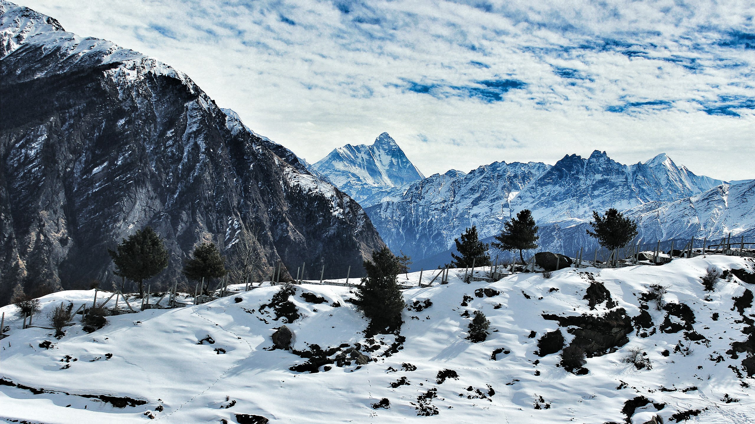
The Himalayas
World's highest mountain range forming India's northern boundary. Home to snow-capped peaks, glaciers, and the source of major rivers.
Indo-Gangetic Plains
Fertile alluvial plains formed by Indus, Ganga, and Brahmaputra rivers. India's most densely populated and agriculturally productive region.
Peninsular Plateau
Ancient triangular landmass rich in minerals. Includes Deccan Plateau, Western and Eastern Ghats, forming the core of peninsular India.
Climate Zones & Monsoon System
India's climate is dominated by the monsoon system, creating diverse climatic zones across the subcontinent
The Indian Monsoon System
Southwest Monsoon (June-September)
Brings 75% of India's annual rainfall. Moisture-laden winds from the Arabian Sea and Bay of Bengal create the wet season, crucial for agriculture and water resources.
- • Arabian Sea branch: Western coast, Western Ghats
- • Bay of Bengal branch: Eastern India, Northeast
- • Onset: Kerala (June 1), Delhi (June 29)
Northeast Monsoon (October-December)
Retreating monsoon brings winter rainfall to Tamil Nadu and coastal Andhra Pradesh. Critical for Rabi crops and water storage.
- • Affects southeastern coast
- • Chennai receives maximum rainfall
- • Cyclonic activity in Bay of Bengal
Tropical Wet
Heavy rainfall (200+ cm), high humidity, evergreen forests
Kerala, coastal Karnataka, Northeast, Western Ghats
Temperature: 24-27°C
Rainfall: 200-400 cm
Tropical Dry
Monsoon-dependent, seasonal rainfall, deciduous forests
Maharashtra, Tamil Nadu, interior Karnataka, Telangana
Temperature: 25-30°C
Rainfall: 75-150 cm
Arid & Semi-Arid
Low rainfall, extreme temperatures, desert vegetation
Rajasthan, Gujarat, parts of Haryana, Punjab
Temperature: 20-45°C
Rainfall: 10-75 cm
Alpine & Montane
Cold climate, snow-covered peaks, coniferous forests
Himalayas, Kashmir, Ladakh, Sikkim, hill stations
Temperature: -10 to 15°C
Rainfall: 100-200 cm
Climate Change Impacts
Temperature Rise
Average temperature increased by 0.7°C since 1900. Heat waves becoming more frequent and intense.
Monsoon Variability
Irregular monsoon patterns, delayed onset, extreme rainfall events affecting agriculture.
Glacial Retreat
Himalayan glaciers retreating, affecting river flows and water security for millions.
Major Rivers
Ganga (Ganges)
Length: 2,525 km
Origin: Gangotri Glacier, Uttarakhand
India's most sacred river, supporting 400+ million people across the plains.
Brahmaputra
Length: 916 km (in India)
Origin: Tibet (Angsi Glacier)
One of the world's largest rivers, creating fertile valleys in Assam.
Godavari
Length: 1,465 km
Origin: Trimbakeshwar, Maharashtra
Second longest river in India, known as "Dakshin Ganga" (Ganges of the South).
Narmada
Length: 1,312 km
Origin: Amarkantak, Madhya Pradesh
Westward flowing river creating the Marble Rocks gorge at Bhedaghat.
Demographics
Population
Second most populous country in the world
Rural Population
Majority live in villages and rural areas
Median Age
Young and dynamic population
Natural Resources & Biodiversity
Mineral Wealth
Coal
4th largest reserves globally (319 billion tonnes)
States: Jharkhand, Odisha, Chhattisgarh
Usage: 70% of electricity generation
Iron Ore
4th largest reserves (25 billion tonnes)
States: Odisha, Karnataka, Chhattisgarh
Quality: High-grade hematite ore
Bauxite
5th largest reserves (2.9 billion tonnes)
States: Odisha, Gujarat, Jharkhand
Usage: Aluminum production
Rare Earth Elements
6th largest reserves globally
States: Odisha, Andhra Pradesh, Tamil Nadu
Usage: Electronics, renewable energy
Forest Resources & Biodiversity
Forest Cover
India has 24.62% forest and tree cover (80.9 million hectares), supporting incredible biodiversity with over 45,000 plant species and 91,000 animal species. The country hosts 4 of the world's 36 biodiversity hotspots.
Very Dense Forest (3.02%)
Canopy density >70%, pristine ecosystems
Moderately Dense Forest (9.59%)
Canopy density 40-70%, managed forests
Open Forest (9.14%)
Canopy density 10-40%, degraded areas
Biodiversity Statistics
Endemism: 33% of flora and 60% of fauna are endemic to India
Water Resources
Surface Water
- • Rivers: 400+ major rivers
- • Annual flow: 1,869 billion cubic meters
- • Utilizable: 690 billion cubic meters
- • Major basins: Ganga, Brahmaputra, Indus
- • Reservoirs: 5,000+ large dams
Groundwater
- • Annual recharge: 432 billion cubic meters
- • Extractable: 398 billion cubic meters
- • Current extraction: 249 billion cubic meters
- • Over-exploited: 1,034 blocks
- • Usage: 89% for irrigation
Coastal & Marine
- • Coastline: 7,516 km
- • EEZ: 2.02 million km²
- • Islands: 1,382 islands
- • Mangroves: 4,975 km²
- • Coral reefs: 2,375 km²
Agricultural Resources
Land Use Pattern
Soil Types
Alluvial Soil (43%)
Indo-Gangetic plains, highly fertile, supports intensive agriculture
Red & Yellow Soil (18%)
Peninsular India, iron-rich, suitable for cotton, sugarcane
Black Soil (15%)
Deccan plateau, cotton soil, high water retention
Laterite & Others (24%)
High rainfall areas, acidic, suitable for plantation crops
Explore India's Geographic Diversity
Discover more about India's diverse landscapes, natural resources, and regional geography that shapes the nation's identity.